
Chasing Storm Signals
- Ladakh, India -
“The land so barren and the passes so high, that only the worst of enemies or the best friends would visit this land."
- Ladakhi saying -
Summary
In the summer of 2013, I participated in a complex and fascinating scientific, mountaineering and photographic field project in the remote, high topography and arid region of Ladakh in the Indian Himalayas. The project was coordinated by the University of Edinburgh Geoscience Department, mainly by Dr Hugh Sinclair, Professor of Surface Geodynamics at the Drummond Institute of Geography in Edinburgh, United Kingdom. The expedition project was sponsored by the Edinburgh University Development Trust through an Innovative Initiative Grant.
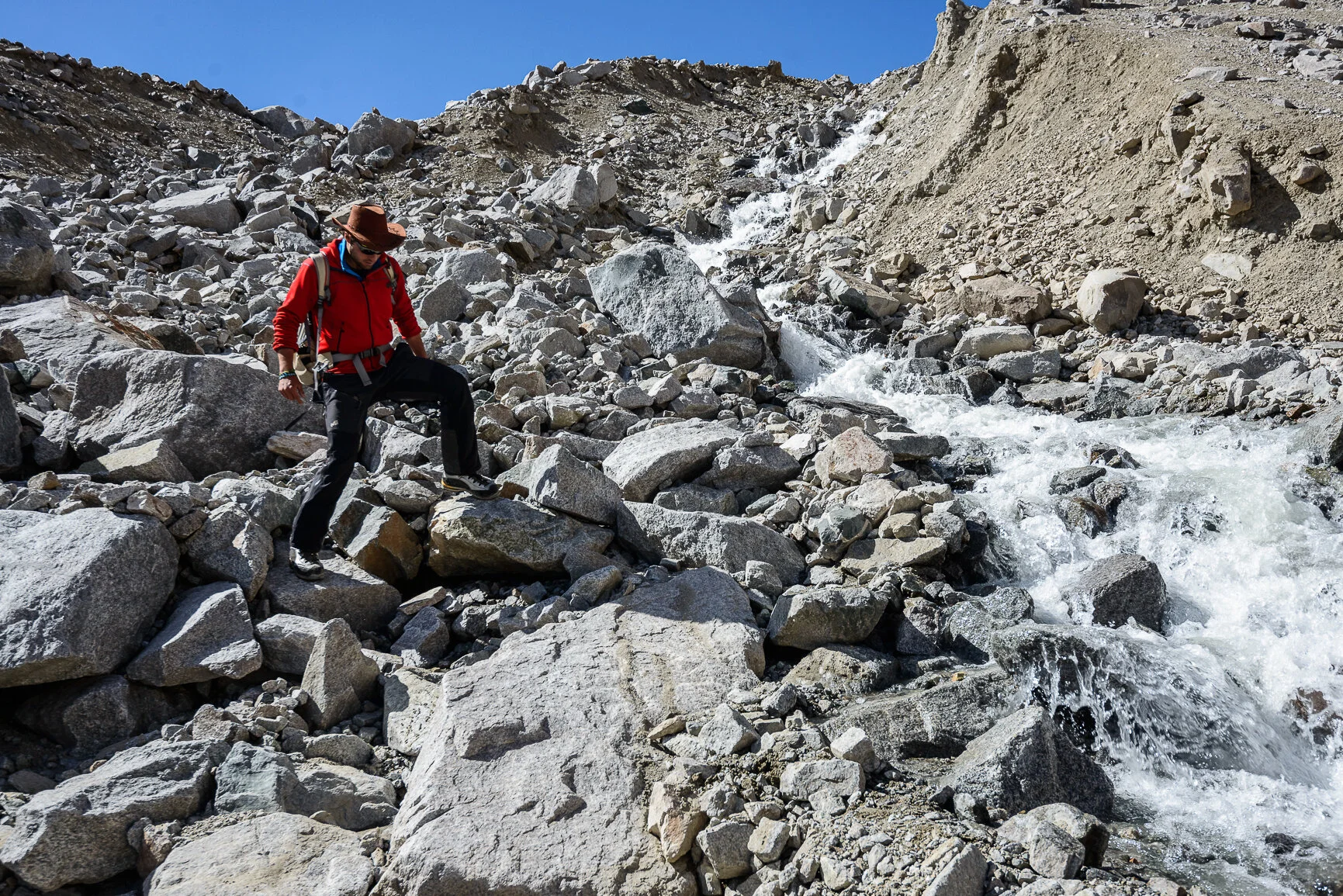
Figure 1. Sergiu exploring a debris flow in Phyang Valley. ©Christopher Rubey, 2013
The expedition team comprised: Sergiu George Jiduc as logistics leader and scientific investigator, Oliver James Forster as a scientific investigator and Christopher Lu Rubey as a photographer. Additionally, two other scientific investigators, Kirstie Dallas and Nick Robert accompanied us in the field, carrying out a slightly different research project.
The main aim of our research project was to investigate the role of glacial lake outburst floods in the 2010 extreme storm event, which resulted in the death of over 600 people and the devastation of over 50 rural settlements. The well-preserved convective storm event in the geomorphic record, combined with increasing scientific literature about the subject provided a perfect case study. Data about the hydrology, geomorphology, topography and the relative age of glacigenic landforms in the valleys of Leh, Phyang, Domkhar and Likkir in Ladakh Range was generated using a variety of techniques which included geomorphological mapping, channel surveying, lichenometric relative dating, photographic analysis, remote sensing and Geographic Information System processing.
Results indicated that the storm impact is variable across the surveyed valleys (>150km) and the correlation with glacial lake outburst floods is not significant. Geomorphic evidence that accounts for the glacial hazard was found in just one valley, Phyang, with the debris flow concentrated in a 1-3 km band in front of a breached moraine dam. Valley geomorphic, geologic and topographic factors inhibit debris flow evolution downstream by reducing its energy and sediment load until complete cessation. Dating of glacigenic landforms using the lichen percentage cover technique is subjective, sensitive to environmental factors and prone to error. However, the photographic technique is effective in producing quantitative data of population sizes.
A brief overview of the study area
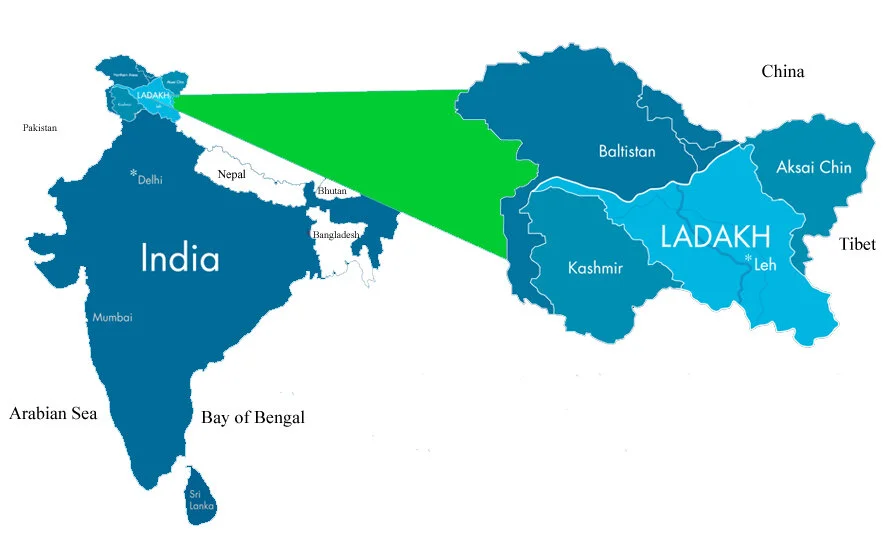
Figure 2. Map of Ladakh and location in India
Ladakh is a remote region located in the northwest part of India, in the state of Jammu and Kashmir (Figure 2). The regions stretch from 33° to 35° latitude North and 76° to 79° longitude East and share India’s northern boundary with Pakistan and China. Ladakh is crossed by a system of mountain ranges running roughly parallel to each other from northwest to southeast. From north to south these are Karakoram, Ladakh, Zanskar and the Great Himalaya ranges, and these determine the course of Ladakh’s rivers. The drainage in Ladakh is provided by the Indus River which runs for approximately 450km and receives a series of glacier-fed tributaries from the north (for example Shyok, Shigar and Gilgit) and the south (Hanle, Zanskar and the Suru Shingo). Most of these lie parallel to the mountain ranges and run along fault lines.
Despite its apparent remoteness, Ladakh was a way station for ancient trade routes — notably the famous Silk Road, which connected China, India, Central Asia, Europe and even parts of northern Africa. In more modern times, the high walls of the Himalayan mountain range and the region’s barren, rocky, high-altitude desert plateaus kept modern travellers at bay until quite recently. It wasn’t until the Indian army constructed the Leh-Manali Road that outside visitors were finally able to access the region — less than forty years ago, in 1974.

Figure 3. Folding layers of rock are exposed upon the flat lands surrounding Rangdum. The rock layers reveal tremendous amounts of geological material spanning back to the earliest periods of Indian history. ©Christopher Rubey, 2013
The climate of Ladakh is typical of a high-altitude arid desert and is characterized by large seasonal and diurnal temperature fluctuations, low mean annual precipitation values, low relative humidity during the summer season and fast blowing winds in the afternoon hours. The summer season is short (May-September) whereas the winter season is long (November-April). Vegetation cover is scarce and discontinuous with cropping areas being limited to the low altitude floors of river valleys, where anthropic irrigation is present. Agriculture is the main income generation means for Ladakhis, although due to the above-mentioned environmental characteristics, agriculture is a difficult and risky affair.
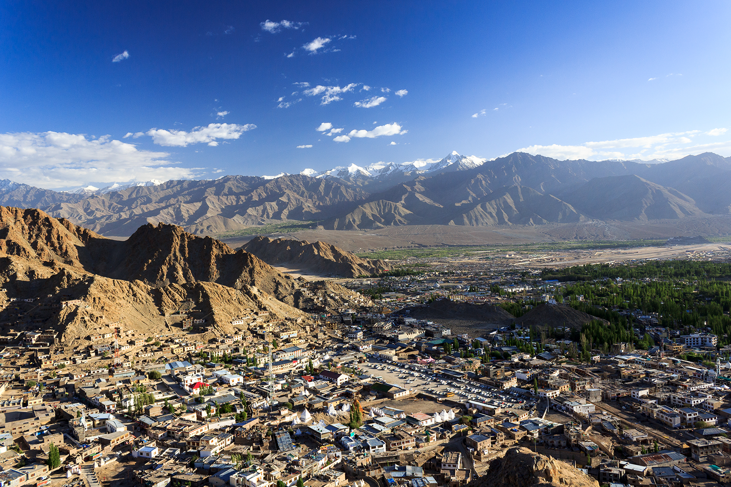
Figure 4. Panorama over Leh City. ©Sergiu Jiduc, 2016
In terms of geology, the Ladakh Range of Transhimalaya is a granodioritic, granitic and tonalitic batholith, with minor amounts of mafic rocks such as diorite, grabbro and grabbronorite intruded by leucogranite dykes. The batholith is part of the Cretaceous - Eocene arc batholiths that developed between India and Asia and are currently entrapped into the collisional zone. Topographically, the Ladakh batholith is aligned west-northwest to east-southeast and rises from the Indus valley floor at about 2300 m in the west and 4000 m in the east. The main ridgeline forms a relatively horizontal summit plane with elevations above 6000m in the west and 5800m in the east.
Leh is the capital and most populous city of Ladakh and is located in a glacial valley adjacent to the Indus River, which flows roughly from southeast to northwest (Figure 4). During the 4-6 August 2010, the area surrounding Leh, experienced a series of flash floods and mud and debris flows that caused serious damage to infrastructure and settlements. Approximately 52 villages with about 1750 houses were destroyed and over 600 people were killed in what was described as the worst storm in living memory. This storm was associated with the intense monsoonal precipitation that caused flooding throughout the lower Indus Valley in Pakistan during July and August 2010.
Scientific Rationale

Figure 5. Conceptual model describing key meteorological elements that led to the anomalous flash-flooding case in Leh. Convective cells on the Tibetan Plateau organised upscale and propagated westwards. The MCS on the edge of the Himalayas taps into the upslope low-level moisture. ©Rasmussen and Houze, 2012
The only meteorological and hydrological reconstruction of the event is based on the Tropical Rainfall Measuring Mission (TRMM) data, which records a 3 day build-up of repeated Mesoscale Convective Systems (MCS) at the mixing boundary between moist monsoonal airflow from the southeast and dry convective systems coming off the Tibetan Plateau (Figure 5) (Kumar et al., 2012; Rasmussen and Huze, 2012); However, the TRMM data has a 3-hour temporal resolution and 28 km spatial resolution, which wrongly locates the storm’s main impact event by over 50km south of the region of devastation (NASA, TRMM, 2010).
Previous investigation of the storm event by Hobley et al. (2012) suggested that:
a) precipitation was constrained by the topography of the range; and
b) the distribution of debris flows that caused the damage correlates with the distribution of intense precipitation, and not the longer-term mean recorded by the Tropical Rainfall Measuring Mission satellite data.
Furthermore, a glacial lake inventory carried out in Domkhar Valley by Narama et al. (2012), suggested that four GLOF events have occurred in the valley since 2000 with the flood of 2003 being the most severe. Additionally, further 12 glacial lakes situated at elevations between 5000 - 5200 m pose medium to high GLOF risk.

Figure 6. Hillshade digital elevation model (DEM) of study area created using Arcmap. The Ladakh Range runs NW-SE corner to corner through the center of the image, north of the Indus River and south of the Shyok River. Investigated catchments of Domkhar, Likkir, Phyang and Leh flowing southwards into the Indus valley (blue). The small, (light green) regions are the glaciated third order tributary catchments investigated in this study.
Observations regarding a) the earlier onset of the Indian monsoon in the late twentieth century that resulted in enhanced June precipitation and overall thermodynamic changes over northwestern Indian continental region (Bolassina et al., 2013), coupled with observations regarding the b) 2010 cloudburst event by Hobley et al. (2012); Thayyen et al., (2013); Kumar et al., (2012); Rasmussen and Huze; c) expansion of glacial lakes and GLOF occurrence in Ladakh Range (Narama et al., 2012) and d) knowledge regarding moraine dam failure mechanisms (Clague and Evans, 2000; Richardson and Reynolds, 2000; Costa and Schuster, 1988); consisted the launch base for this research and the formation of the research hypothesis:
a) (H1): Glacial lake outburst floods played a significant role in the Ladakh 2010 storm event. The short-lived high rainfall event disrupted the equilibrium of the meltwater drainage system through the moraines leading to catastrophic flooding in the form of highly mobile debris flows that devastated communities downstream.
b) (H2): Glacial lake outburst flood involvement in the 2010 storm event was not significant. The glacial hazard is common and restricted to the high (>5000m asl) glaciated valleys of Ladakh Range, however it does not impact the lower reaches of the valley where communities are located.
This specific objective of this study are to a) quantify the distribution of 2010 GLOF’s, b) to assess flood triggering mechanisms, and c) to investigate moraine morphology and meltwater drainage mechanisms. The Ladakh Autonomous Hill District Council has supplied a full list of valleys that were reported as having been impacted by the storm event. From the list, we chose to investigate the valleys of Leh, Phyang, Domkhar and Likkir (Figure 6).
High Himalaya Mission
We organized a daring trip in the second week of our stay in Ladakh into the High Himalaya range, situated south of the Indus River. The aim was to visit the infamous Kargil, near the border of Pakistan and reproduce a historic photograph of the Drang Drung Glacier, located some 200km southeast of Kargil in the Himalaya (Figure 7). The journey by bus along the Indus valley was a wild adventure, crossing high passes some 4500m high and negotiating numerous roadblocks. The journey from Kargil to Pensi La via the notorious Suru Valley proved to be a rather difficult endeavour due to the rough character of the road. Thankfully our hired driver proved to be quite skilled in negotiating the numerous obstacles along the road. Fantastic jagged 7000m peaks such as Kun and Nun kept us in high spirits for the duration of this journey. Camping next to the Drang Drung glacier was also a highlight, especially when our attempted stir-fry dish proved to be a complete disaster. A balanced ratio of elements in a dish is crucial for a tasty meal – too much ginger just ruins it!
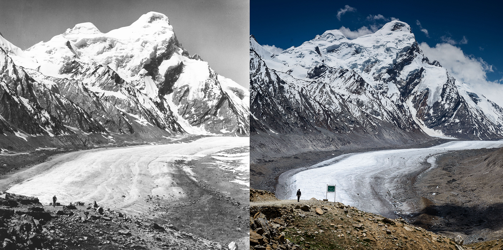
Figure 7. Drang Drung Glacier, High Himalaya as seen from Pensi La (N 33.9377 / E 76.3686), left in 1980 and right in 2013. Man standing on path in the left side is used to estimate the scale o the image. Camera pitch orientation (azimuth toward direction of shot): 194°, elevation of camera position, 4383m. Camera type: Nikon D800; focal length: 70mm. (Left) ©Kirch Dieter, German Alpine Club, (Right) ©Christopher Rubey, 2013. Weathered conditions: sunny/ scattered clouds, wind blowing from west at about 1.5m/s.


Leh Valley - getting used to fieldwork area
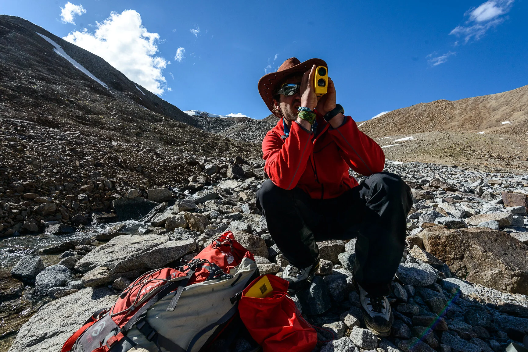
Figure 8. Sergiu Jiduc using a laser-range finder for geomorphic mapping - a key component of the research methodology. ©Christopher L. Rubey
The first valley we explored was Leh, located just near Khardung La – the highest motorable pass in the world (5642m). In this valley, we calibrated and tested our long-range lasers, handheld transceivers, altimeters, compass, DLSR cameras and also acclimatized to the high altitude conditions. Unfortunately, while testing our weather station we realized that it was not suitable for the harsh weather conditions of this high altitude environment and we decided to abandon the weather data-gathering mission. We would later use climate data gathered by a nearby weather post installed by the Indians. Nevertheless, we did manage to gather some useful geomorphic data (Figure 8) and get accustomed to this unique but harsh landscape. Some of the preliminary observations indicated a poor correlation between the debris flow and glacial lake outburst floods in this particular valley.
Phyang Valley
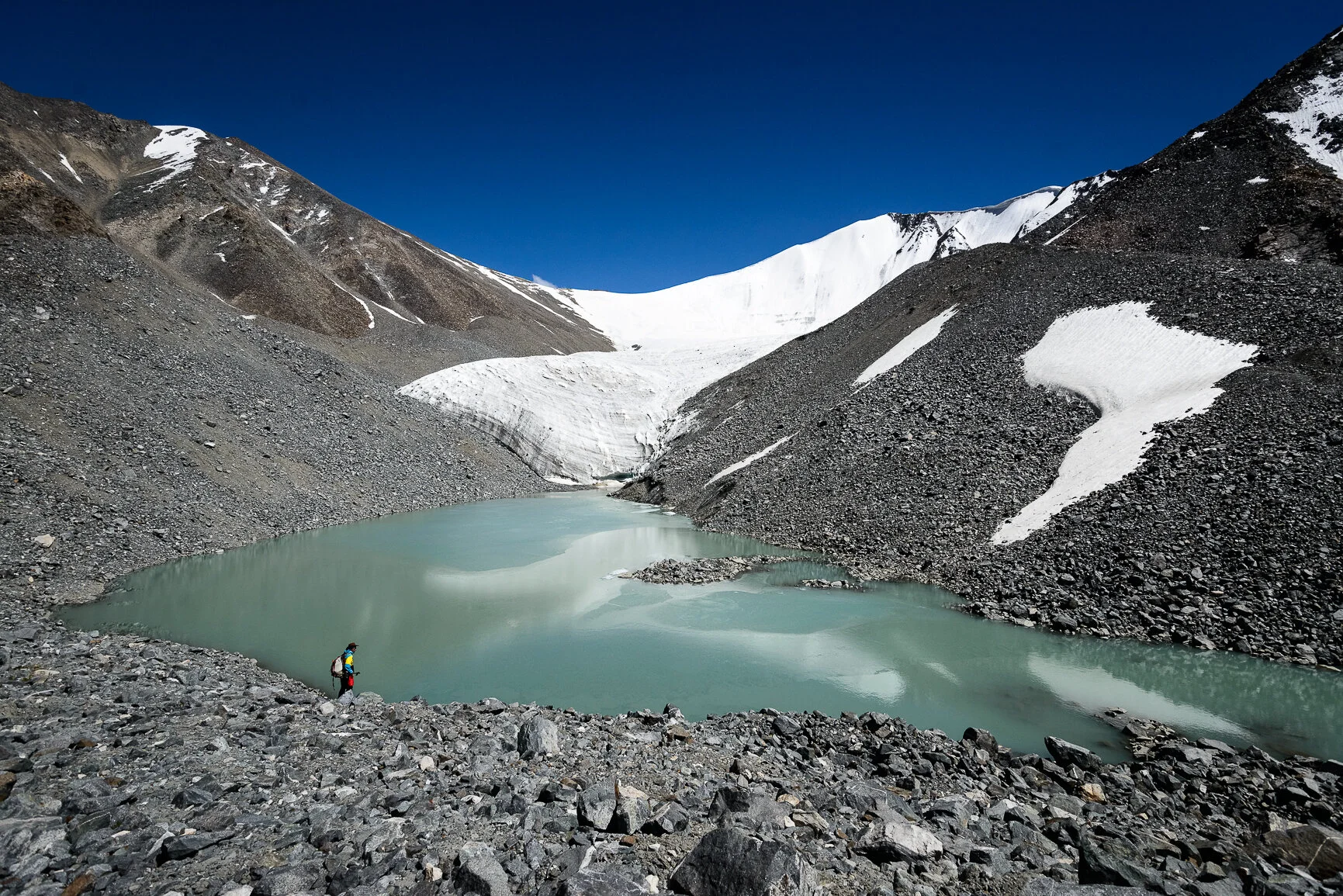
Figure 9. North East Phyang Valley Glacier, Ladakh Range. Photograph taken from reference point (1), at 5259 m asl located on end moraine. Field of view is approximately 450m across. Note the ice tunnel on the right hand side of the photograph, draining the lake. ©Christopher Rubey, 2013
The second valley we explored was Phyang (Figure 9) , which is located west of Leh valley. From this valley came a series of anecdotal reports from villagers of debris flows coming from the uppermost sections of the valley above 5000m. Therefore, we were particularly interested to follow these debris flows to their source and assess what was the triggering mechanism. Armed with high altitude camping, cooking and scientific equipment and burning curiosity, we trekked the long Phyang valley starting at about 4000m and following closely the poorly sorted debris flow. We reached a bizarre bifurcation in the debris flow at about 5000m. One large and relatively fresh debris flow headed left whereas a smaller, better sorted and much older one continued up the valley heading slightly right. We set up camp at this interesting location. Dinner consisted of a large portion of rice with salt and pepper and a bowl of spicy noodle soup. We were too tired and hungry to complain about the minimalistic dish I would say it was rather delicious at that high elevation.
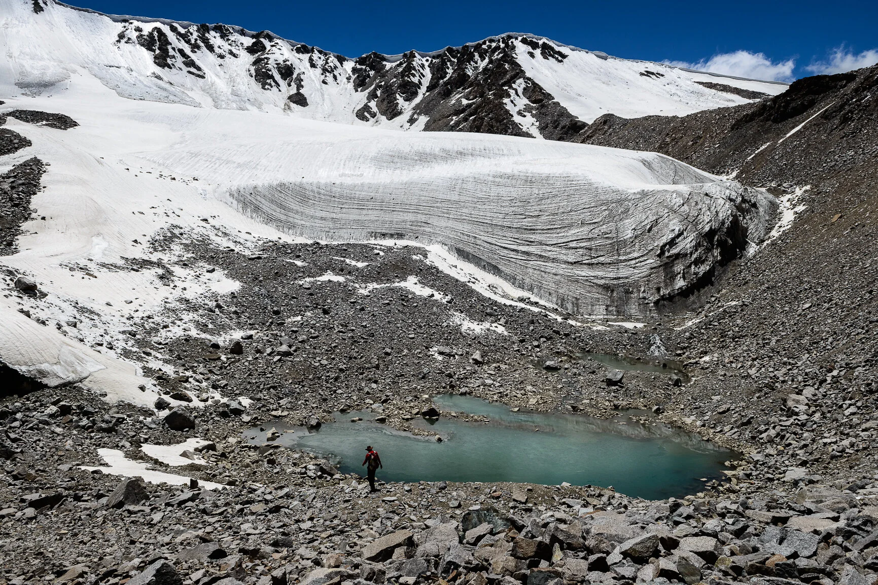
Figure 10. North West Phyang Valley Glacier, Ladakh Range. Photograph taken from reference point (14), 5390m asl on end moraine. Field of view is approximately 300m across. ©Christopher Rubey, 2013.
A large yak herd was grazing undisturbed by us, about 400 meters from our tents. The night was cold and for some of us, slightly unpleasant due to headaches caused by the low oxygen concentration. At about 5 am we were woken up by the howls of a large pack of wolves. Fortunately, they did not dare to attack us. Early the next morning, we all went to explore the eastern, secondary valley and its associated debris flow. Three hours later we reached the terminal moraine of the glacier. There was no geomorphic evidence indicative of debris flow or a breach in the moraine. The glacier was calving into a glacial lake that in turn was draining through the base of the terminal moraine through a series of conduits. I carried out my geomorphic measurements and returned to the camp later in the afternoon, quite content with the work I had managed to achieve. The next day, we investigated the western valley (Figure 10) characterized by a prominent, fresh and poorly sorted debris flow. Just as expected, the debris flow was coming from a breached terminal moraine. The breach was rather spectacular and consistent with the hypothesis of our study until proven otherwise. There were several indications of a glacial lake outburst flood, for example, a drained glacial lake, enlarged drainage conduits, blasted dead ice, two large moraine breaches, and poorly sorted angular to sub-angular material. I spent five days mapping both glacial systems, crafting detailed geomorphic graphic descriptions. Additionally, quantitative data was gathered from the debris flow, which in turn was used to estimate the volume of material dislodged during the event. Oliver was working further downstream performing similar geomorphic and hydrologic measurements.
Domkhar Valley
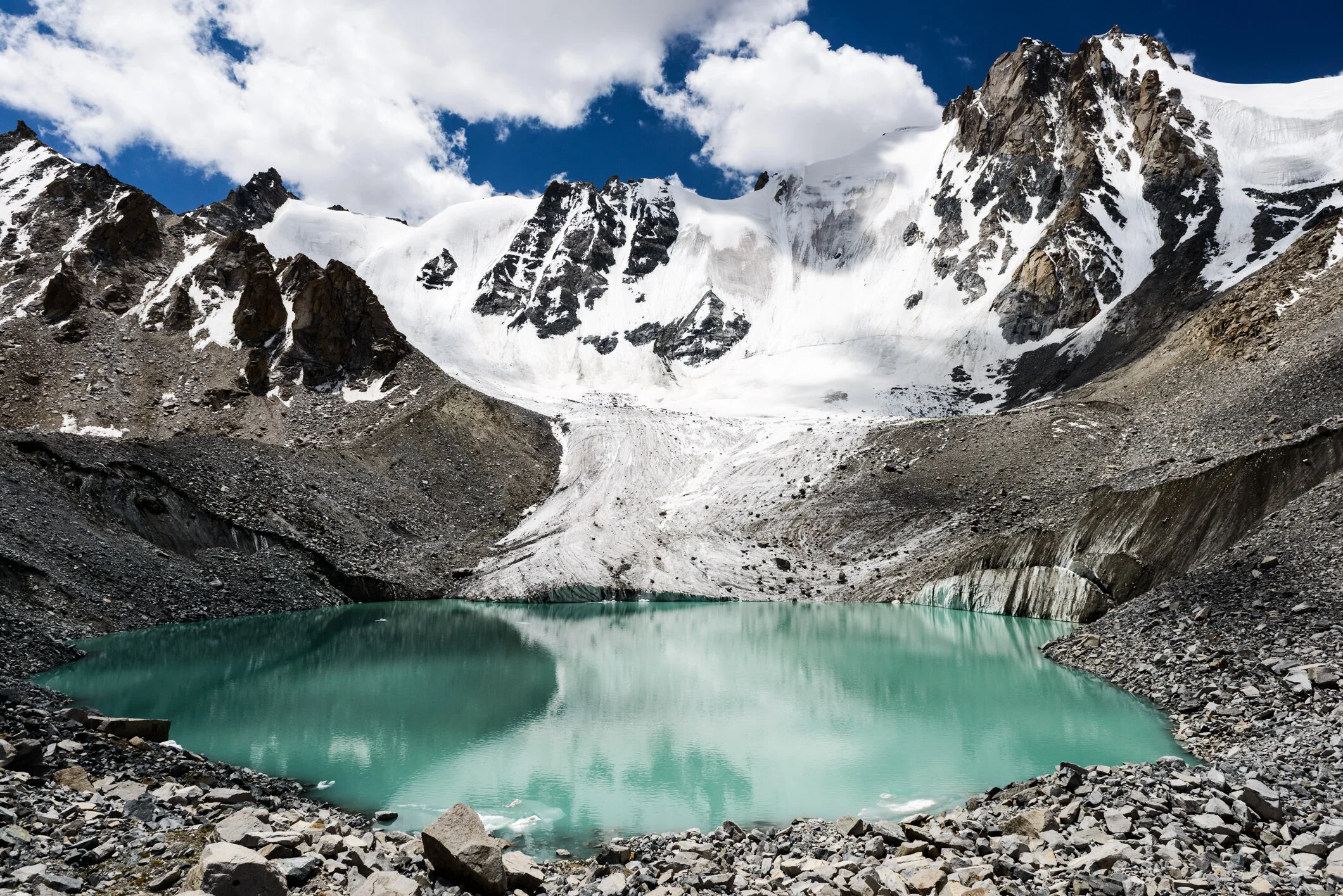
Figure 11. Domkhar Valley Glacier number 3, located in the Gompa Rangchong tributary Valley. Image taken from reference point (14), at 5065m asl on terminal moraine. Field of view is approximately 350m across. Note the steep calving glacier terminus and the debris covering the right (west) flank of the glacier. ©Christopher Rubey, 2013
Domkhar valley was the most spectacular and loftiest valley we explored (Figure 11). Jagged peaks, a series of cirque and dramatic hanging glaciers, fast-flowing glacial streams and a sinister atmosphere, all gave us some “chills”. We asked two Nepali Sherpas to help us carry our heavy loads from village to campsite in the eastern secondary valley. These individuals turned out to be very skilled chefs and they taught us how to properly cook the rice at this altitude. They also taught us how to smoke biddies – some tobacco rolled in eucalyptus leaves – a rather strong delight in this area. Domkhar valley was very complex; there were at least three main glacial systems of which we managed to map only one. The terrain was very rugged and steep and in one area there was geologic evidence of a collapsed glacial system. The lateral and terminal moraine systems were very clear and it was a real pleasure photographing and analyzing the lichen cover on these clean surfaces to determine their relative age. I have found little evidence supportive of a GLOF event in this glaciated catchment. However, I believe there is considerable risk of a GLOF event occurring in one of the three glacial systems in the near future. This is due to a combination of factors including a high lake level, serac and rock avalanches into the lake, dangerously expanding sub-drainage conduits and a high narrow moraine wall.
Likkir Valley
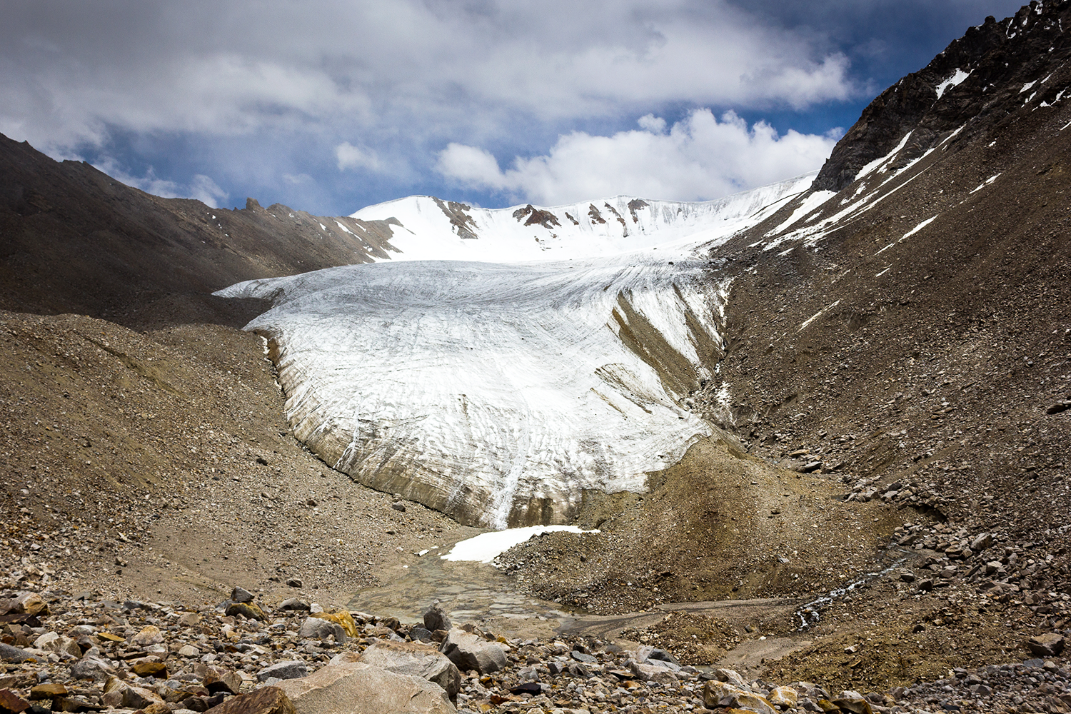
Figure 12. Likkir Valley hosts a small glacier which shows signs of becoming a rock glacier. ©Sergiu Jiduc, 2013
This valley was the most sinister and mysterious of all the places we had seen so far. Here I was faced with a fierce Himalayan storm that almost knocked me down while examining the glacier. Besides this scary event, our geomorphic investigation suggested that the storm signal has missed the uppermost section of the valley and was rather concentrated downstream just above the Likkir village. The valley seemed blank with no major catastrophic geomorphologic phenomena (Figure 12) . Some peculiar geomorphic features such as a series of closely packed terminal moraines and flat, silty-muddy rich beds with stagnant water, created some considerable confusion when interpreting the train of events that have occurred in this valley. We managed to take some data but insufficient to determine a strong storm signal in this location. Strangely enough, this valley was located in between Phyang and Domkhar – two valleys with a strong geomorphic signal. We returned to Leh, not missing, of course, the giant golden Buddha statue.


Conclusion
The results of this study indicated that the storm impact is variable across the surveyed valleys (>150km) and the correlation with glacial lake outburst floods is not significant. Geomorphic evidence that accounts for the glacial hazard was found in just one valley, Phyang, with the debris flow concentrated in a 1-3 km band in front of a breached moraine dam. Valley geomorphic, geologic and topographic factors inhibit debris flow evolution downstream by reducing its energy and sediment load until complete cessation. The relative dating of glacigenic landforms using the lichen percentage cover technique is subjective, sensitive to environmental factors and prone to error. However, the photographic technique is effective in producing quantitative data of population sizes. Qualitative analysis of repeat photographs in High Himalaya based on the case of Drang Drung glacier indicated a pronounced melting trend, which has accelerated since 1980.
A question arises from this research: If precipitation intensity and frequency of high intensity rainfall events during the Indian Summer Monsoon continues to increase as result of climate change; will future GLOF’s be able to propagate further downstream as result of increased potential energy of glacial lakes and reduced structural resistance of moraine? When coupled with the widespread glacial recession that threatens to drastically reduce water supplies in this arid environment, the vulnerability of mountain communities is highly increased. Solution to the latter issue could consist the construction of artificial glaciers. Such artificial glaciers have been constructed in Ladakh and show positive results such as: early spring availability of meltwater and facilitation of early crop cultivation.
Bibliography
Bollasina, M. A., Ming, Y., and Ramaswamy, V. 2013. Earlier onset of the Indian monsoon in the late twentieth century: The role of anthropogenic aerosols. Geophysical Research Letters. 40: 3715 – 3720.
Hobley, D. E. J., Sinclair, H. D., and Mudd, S. M., 2012. Reconstruction of a major storm event from its geomorphic signature: the Ladakh floods, 6 August 2010. Geology v. 40 (6) p. 483-486.
Hobley, D. et al., 2010, Processes, rates and time scales of fluvial response in an ancient post-glacial landscape of the northwest Indian Himalaya, GSA. Bull., 122, 1569-1584
Hobley, D. E. J., Sinclair, H. D., Mudd, S. M, and Cowie, P. A. 2010. Processes, rates and time scales of fluvial response in an ancient post-glacial landscape of the northwest Indian Himalaya, Geological Society of American Bulletin. 122: 1569-1584.
Kumar A., Houze, R. A., Rasmussen, K. L., and Lidard, P. C., 2012. Simulation of a flash-flooding storm at the steep edge of the Himalaya. Journal of Hydrometeorology.
Rasmussen, K. & Houze, R., (in press). 2012 A flash flooding storm at the steep edge of high terrain: Disasater in the Himalayas. Bulletin of American Meteorological Society.
Thayyen, J. R., Dimri, A. P., Kumar, P., and Agnihotri. 2013. Study of a cloudburst and flash flood around Leh, India during August 4-6, 2010. Natural hazards. 64: 2175-2204.