
Landscape Changes in Cordilleras Blanca & Huayhuash
- Peru -
“Solo los gringos y los burros caminan en el sol”
“Only foreigners and donkeys walk in the sunshine”
— Old Andean Proverb
Abstract
Landscape changes in the Cordillera Blanca and Cordillera Huayhuash of Peru between 1936 and 2012 were documented, focusing on glacier and vegetation cover, as well as changes in the cultural landscape. Repeat photography (an analytical tool capable of broadly and rapidly providing clarifications regarding landscape and land use changes within a given region) was the principal method used, along with oral testimonies and literature reviews. The base material used for the research consisted of historic photographs taken by the German and Austrian Alpine Club (Alpenverein) Expeditions to the Cordillera Blanca in 1936 and 1939, as well as photographs taken by F. D. Ayres in 1954 for the National Snow and Ice Data Center in Boulder, Colorado. Results suggest that since 1936 the Cordillera Blanca and Cordillera Huayhuash have experienced widespread glacier recession and the formation of new glacier lakes. In terms of the vegetative landscape, the native Polylepis forest cover appears to have remained stable, whereas the area covered by non-native Eucalyptus and Pinus species appears to have increased. At the same time, the cultural landscape clearly shows urban expansion.
This article describes the assessment of landscape changes in detail. If you are interested in the more adventurous elements of the project, then please read the expedition journal.
Introduction

Figure 1. Physical map pof Peru. The dotted square is the study area for this project comprising Cordillera Blanca and the Cordillera Huayhuash.
The Cordillera Blanca and Cordillera Huayhuash are the most prominent mountain ranges in all of Peru (Figure 1). The Cordillera Blanca (Figure 2) is a straight mountain chain, 180 km long, striking NNW to SSE, and running parallel to the coast from 8°5’ S to 10° S latitude. It also forms the main watershed of Peru’s coastal region. From a geologic perspective, the Cordillera Blanca is made of plutonic rocks that have penetrated the upper layers of the Earth’s crust. These rocks consist mainly of light colored granodiorite (intrusive igneous rock containing more plagioclase than orthoclase), and can be found in glaciated areas forming the base of the peaks. Stratified rocks such as black slate (foliated, homogenous, metamorphic rock) surround the granodiorite. These are folded and strongly compressed towards the crests (Kinzl and Schneider, 1950).

Figure 2. Cordillera Blanca Repeat Photography Stations. ©Google Earth, 2020
The Cordillera Blanca offers some of the best mountaineering in South America. Its advantageous position in relation to traffic routes and exceptional high summits make it an accessible and popular high altitude destination. In terms of climate, the Cordillera Blanca has a tropical climate with two main seasons (i.e., dry and wet) alternating according to the distribution of rainfall. The rainy season begins in November and ends in April, reaching its greatest intensity between January and March. The dry season occupies the remaining months and is considered to be the best season to visit the two cordilleras.
The Cordillera Huayhuash (Figure 3) is a compact sub-region of Cordillera Occidental, 30km long and striking NNW to SSE, running fairly parallel to the coast from 10°8’ S to 10°24’ S latitude. It contains sharp summits, six of which exceed 6000 m. The geology of the Huayhuash is comprised of limestone, inter-bedded with sandstone and shale. Volcanic activity is also present in the form of cinder cones, hydrothermal alteration (e.g. sulphate minerals and iron oxide), and vertical hexagonal columns comprising lithic tuff. In some limestone beds, marine fossils such as ammonites and bivalves can be found. The Cordillera Huayhuash is home to some of the most spectacular and difficult alpine climbing in all of the Andes and is considered by many to be one of the best trekking regions in the word (Frimer, 2003).

Figure 3. Cordillera Huayhuash Repeat Photography Stations. ©Google Earth, 2020
The Cordillera Huayhuash is a compact subregion of the Cordillera Occidental, 30 km long and striking NNW to SSE, running fairly parallel to the coast from 10°8’ S to 10°24’ S latitude. It contains sharp summits, six of which exceed 6000 m. The geology of the Huayhuash is comprised of limestone, interbedded with sandstone and shale. Volcanic activity is also present in the form of active geothermal areas, hydrothermal alteration (e.g., sulphate minerals and iron oxide) and hot springs. In some limestone beds, marine fossils, such as ammonites and bivalves, can be found. The Cordillera Huayhuash is home to some of the most spectacular and difficult alpine climbing in all of the Andes and is considered by many to be one of the best trekking regions in the world (Frimer, 2005). The Huascarán National Park is situated in Ancash Department in the north-central part of Peru and includes most of the Cordillera Blanca. The national park was established in 1975 and was declared a UNESCO Biosphere Reserve in 1977. The park contains 60 peaks with altitudes above 5700 m, the highest being Huascarán South at 6768 m. Forty-four glacial valleys transect the range from both west and east. The terrain below 4800 m is characterized by high altitude grassland (puna) with remnant quenual (Polylepis sp.) forests located within the upper inner valley slopes. The Polylepis forest cover hosts a highly diverse flora and fauna and provides habitat for several endemic species of Andean birds. Unfortunately, humans have drastically reduced the area covered by Polylepis forest during the past century, and currently only 3 per cent of the original forest remains intact. West of the national park lies the agricultural and earthquake-prone valley of the Santa River, a densely populated region containing cities such as Huaraz (130,000 inhabitants), Caraz (11,000 inhabitants), and hundreds of rural settlements. These cities are relatively prosperous, although most rural inhabitants still rely on subsidence agriculture as their means of living. Incomes are mainly based on agriculture, livestock, and a growing tourism sector, especially on the western side of the park. Important environmental issues exist in the area. They include overgrazing of alpine and subalpine pastures, concentrated tourism, uncertain land titles and park boundaries, government policies supportive of resource extraction within the national park, and subsequent external pressures such as new roads, mining, dams, and tourist infrastructure. However, during 1995 and 1996, The Mountain Institute (TMI), along with governmental, non-governmental, private sector and local communities produced the Huascarán National Park Ecological Management Plan, the country’s first participatory plan for protected areas (Byers, 2000). TMI has continued to work in the region, along with a range of other non-governmental organizations, in the fields of education, cultural conservation, alpine restoration, climate change, and water supply.
Methodology

Figure 4. Cross-referencing historic photographs and maps with local community knowledge. ©Sorin Rechitan, 2012
Between the 1930s and the 1950s, the Deutscher und Österreichischer Alpenverein (DuÖAV) and Deutscher Alpenverein (DAV) expeditions produced the world-renowned Alpenverein maps, using terrestrial photogrammetry from mid- to high-altitude photopoints. Moreover, thousands of glass plate negatives and Leica photographs were also produced, which are scattered across Europe in various collections. These historic landscape photographs provide a unique opportunity to qualitatively document contemporary landscape changes (Byers, 2000). Repeat photography is an analytical tool capable of broadly and rapidly providing preliminary clarifications related to landscape and land use changes within a given region and was the main research tool used in this study. Literature reviews and oral testimony from local people and scientists were also used in our efforts to interpret and describe apparent changes between the older photographs and our newer repeat photographs. The equipment used included a Canon EOS MK III DSLR camera with three different lens systems: (1) EFS18-55mm f/2.8, Canon 24-105mm f/4 IS, and Canon EF 70-300mm f/4-5.6 IS; (2) a Canon EOS 550D DSLR camera with two lens systems; and (3) a Canon EFS 18-55mm, f/3.5-5.6 IS, Tamron AF 28-300mm f/1:3.5-6.3 IF, and a Panasonic DMC LX2 28mm digital compact camera. For the video documentation of our expedition, we used a HD Sony Handycam and a Go Pro Hero 2 video camera.

Figure 5. Cross-referencing historic photographs with local community knowledge. ©Sorin Rechitan, 2012
Ideally, historic photographs should be replicated using the precise equipment used by the original photographer. Season, time, date and weather conditions should also be replicated as closely as possible (Byers, 2000). This was quite challenging due to budgetary and time constraints, the remoteness and high altitude of the photopoint locations, and the difficult working conditions. Nevertheless, the overall objective to accurately replicate a range of historic photographs was met (Figure 4). The Alpenverein maps used for our research included the 1932 DuÖAV (Deutschen und Österreichischen Alpenvereins, Munchen) “Cordillera Blanca y el Callejón de Huailas (Peru)” (Figure 5). This map is commonly referred to as the “Parte Norte” or “North Sheet” of the Cordillera Blanca. The 1939 DAV (Deutschen Alpenverein, Innsbruck) “Cordillera Blanca (Perú) Parte Sur” map was also used. Other maps included the 1939 DAV Cordillera Huayhuash Expedition “Cordillera de Huayhuash (Peru)”, and the DAV “Alpenvereinskarte Cordillera Huayhuash”, published in 2008.
Results and Discussion
Our expedition managed to reproduce 21 pairs of photographs, 14 of which are shown and described below.
1. Nevado Ranrapalca (6,126 m)
Date: 08.08.2012
Aspect: 272°
Time: 12:41
Map Station: S24
Altitude: 5028 m
Original: DuÖAV, 1936

Figure 6. (Left) Nevado Ranrapalca 6126 m. ©DuÖAV, 1936 Figure 7. (Right) Nevado Ranrapalca 6126m. ©S. Jiduc, 2012
The thinning and retreat of several hundred meters of ice is clearly apparent when comparing the two photographs above (Figure 6 and 7). The formation of a new glacial lake in the cirque depression at the bottom on the SE side of Ranrapalca (right hand side of Figure 7) is due to the meltwater runoff sourcing the ice and snow cover above. The erosive effect of glaciers can also be observed.
2. Glacial Lake Palcacocha, Quebrada Cojup
Date: 08.08.2012
Aspect: 01°
Time: 13:04
Map Station: S24
Altitude: 4991 m
Original: DAV, 1939

Figure 8. Glacier Lake Palcacocha, Q. Cojup. ©DAV, 1939 Figure 9. Glacier Lake Palcacocha, Q. Cojup. ©S. Jiduc, 2012
Palcacocha is a tropical glacial lake subject to glacial lake outburst floods (GLOFs). On December 13, 1941, an ice avalanche from a hanging glacier on Pucaranra – Palcacocha fell into the impounded Palcacocha Lake shown in Figure 5, causing the breaching of the terminal moraine that contained the lake. A massive wave swept down the entire Cojup Valley, and also subsumed the water of another lake, Laguna Jircacocha, situated 2-3 miles downstream. The combined water of the two lakes descended onto Huaraz, carrying debris, boulders, ice, and liquid mud. Approximately 1,800 people died and the northern third of the city was destroyed (Wegner, 2014: 41-42). The approximate arrival time of the flood from its initiation to Huaraz was estimated at 22 minutes, with the peak in downstream discharge produced at about 33 minutes after the breach (Rivas, 2012). The flood drained a large volume of water from Palcacocha Lake as shown in Figures 8 and 9. Image comparison also shows widespread glacier recession, especially in the center and left hand side of the photographs. Ice thinning is also present on Palcaraju (6274 m). New geomorphic features such as gullies, sumps, and torrents have also formed. Climate change is accelerating the retreat of tropical glaciers in Peru with hydrological consequences such as increases in glacial lake volume (Rivas, 2012). Although the 1941 GLOF event drained a substantial amount of water, the volume of Palcacocha Lake has increased from 1941 to 2010 by more than 7 million cubic meters. Recent studies have suggested that a flood today could kill between 2,800 and 6,125 people (Somos et al., 2013; Cuéllar, 2016). Although an attempt to lower the level of Palcacocha with siphons did not produce the desired results, the Ministry of Environment funded a project in 2013 to design an early warning system (EWS), following the glacier research and community consultation activities of the USAID-funded High Mountains Adaptation Partnership (HiMAP), implemented by TMI/Peru (Cuéllar, 2016).
3. Glacial Lake Palcacocha, Quebrada Cojup
Date: 08.08.2012
Aspect: 038°
Time: 09:18
Map Station: S39
Altitude: 4525 m
Original: DAV, 1939

Figure 10. Glacier Lake Palcacocha, Q. Cojup. ©DAV, 1939 Figure 11. Glacier Lake Palcacocha, Q. Cojup. ©S. Jiduc, 2012
This set of photographs (Figures 10 and 11) shows the evolution of Palcacocha Lake and recession of the glaciers that surround the lake. Comparison between the old and recent photographs shows that widespread glacier retreat and thinning has occurred in the interim, especially in the center of Figure 8, and the accumulation of moraine debris, probably due to erosion and rock avalanches. The size of the lake has also increased substantially since 1941 due to the retreat of the glacier.
4. Breach of the moraine dam, Quebrada Cojup
Date: 07.08.2012
Aspect: 020°
Time: 17:25
Map Station: S1
Altitude: 4368 m
Original: F. D. Ayres, 1954

Figure 12. Breakthrough Morainal Dam, Q. Cojup. ©F. D. Ayres, 1954 Figure 13. Breakthrough Morainal Dam, Q. Cojup. ©S. Rechitan, 2012
Figures 12 and 13 show the moraine breach that resulted from the 1941 ice avalanche and flood. The terminal moraine wall was estimated to be approximately 45 m high. Comparison between the two images shows an apparent increase in the width of the breach region, most likely due to erosion and use of boulders for the construction of the dam and drainage system. The debris flow that accompanied the flood can be clearly seen in Figures 10 and 11. Puna (alpine) grassland appears to have covered some parts of the terrain. Significant shrinkage and thinning of the Pucaranra and Palcaraju glaciers is also apparent.
5. Glacial Lake Artesonraju, Quebrada Parón
Date: 15.08.2012
Aspect: 350°
Time: 14:30
Map Station: S37
Altitude: 4297 m
Original: DAV, 1939

Figure 14. Glacier Lake Artesoncocha, Quebrada Parón. ©DAV, 1939 Figure 15. Glacier Lake Artesoncocha, Quebrada Parón. ©S.Jiduc, 2012
Figures 14 and 15 clearly show the significant loss of ice cover that has occurred over the past 73 years. The rock face in the center of the images is approximately 300 m high, and the entire hanging glacier has disappeared. The lake also appears to have increased substantially in size and volume. The large seracs present in Figure 12 on the southwest face of Artesonraju have shrunk considerably. Based upon interviews with local people, river runoff is said to have increased since 1939. Because of the importance of the hydrological contributions of Parón Valley, this area has received some of the most detailed studies of any region within the Cordillera Blanca.

Figure 16. New glacial lake at the head of Parón Valley. ©S. Rechitan, 2012
6. New glacial lake in the Parón Valley
Date: 12.08.2012
Time: 16:45
Altitude: 4850 m
Aspect: 22°
Figure 16 shows the Parón Glacier located between Artesonraju and Piramide. The glacier has retreated some 300 m, forming a new glacial lake. A monitoring station, which measures glacier melt rate, snowfall, solar radiation intensity, wind speed, humidity and precipitation, has also been installed on the glacier. These measurements are important to assess the condition of the glacier and lakes, and thus prevent a sudden outburst flood. Such an event would be disastrous for the communities located downstream, such as Caraz.
7. Laguna Parón
Date: 11.08.2012
Aspect: 057°
Time: 15:03
Map Station: S38
Altitude: 4346 m
Original: DAV, 1939

Figure 17. Laguna Parón as seen from moraine. ©DAV, 1939 Figure 18. Laguna Parón y Nevado Pirámide. ©S. Rechitan, 2012
Laguna Parón is the largest lake in the Cordillera Blanca and was formed as a natural moraine reservoir (Figures 17 and 18). The lake has been used for the Cañón del Pato hydroelectric plant. An interview with an employee informed us that the catchment area of the lake is 44.3 km2, and that the lake is 3.7 km long (E-W), 700 m wide (N-S), and had an original depth of about 75 m. Today the level of the lake is about 15 meters lower to prevent the collapse of the moraine. Comparison between the photographs shows a decrease in water level and volume of the lake since 1939. This level drop is the result of anthropic control in order to prevent a collapse of the moraine. Now, the water level is controlled by a system of tunnels, valves and an underwater gate to keep the water level at 4155 m, aiming to achieve the double objective of flood prevention and provision of downstream irrigation services. The high concentrations of dissolved lime give the water of Parón a turquoise color.
8. Yerupajá (6,617 m) as seen from Laguna Carhuacocha
Date: 21.08.2012
Aspect: 230°
Time: 08:20
Map Station: S43
Altitude: 4138 m
Original: DuÖAV, 1936

Figure 19. Yerupajá seen from Laguna Carhuacocha. ©DuÖAV, 1936 Figure 20. Yerupajá seen from Laguna Carhuacocha. ©S. Jiduc, 2012
Glacier recession also occurs in the Cordillera Huayhuash. Figures 19 and 20 show the Yerupajá East Glacier, which has lost an estimated 200 m of ice since 1939. Most of the hanging ice has been lost through the collapse of seracs and avalanches. Recession is also present on the left hand side of Figure 20, on the col between Yerupajá and Siulá Grande. We observed an increase in the number, size and frequency of crevasses on all the glaciers explored. Many climbing routes established in the 1970s are now impracticable and unsafe due to the massive crevasses and bergschrunds that have developed across the entire mountain faces, some of them being 40 m wide or more. The team encountered difficulties crossing these new crevasses and bergschrunds while attempting to climb Yerupajá Grande’s West Face. The route descriptions from the 1970s, such as those presented in Frimer (2005), acknowledged the existence of these large crevasses and bergschrunds, but they were considered safe to cross at that point in time. However, today these crevasses are often far too wide to cross. Low latitude glaciers are sensitive indicators in the climatic system. The atmosphere in the low latitudes is thermally homogenous in space and time and, thus, seasonality is caused by the annual cycle of atmospheric moisture content. Therefore, low latitude glaciers, such as the ones in Cordillera Blanca and Huayhuash, show seasonal fluctuations or changes in the seasonality of moisture related to climate variables, besides the thermally induced variations. Drier atmospheric conditions may have affected the Cordillera Huayhuash in recent years, accelerating the melting of glaciers.
9. Huascarán seen from Yungay cemetery
Date: 06.08.2012
Aspect: 058°
Time: 15:04
Map Station: S21
Altitude: 2657 m Original: DAV, 1939

Figure 21. Huascarán seen from Yungay cemetery. ©DAV, 1939 Figure 22. Huascarán seen from Yungay cemetery. ©S. Rechitan, 2012
In 1970, Yungay city and Ranrahirca village were completely destroyed and buried under a thick layer of liquefied mud, ice, and large boulders from Huascarán, triggered by a 7.7 magnitude earthquake. The earthquake caused the collapse of a large hanging glacier located on the west face of Huascarán North, turning into a deadly debris flow that jumped over a mountain and completely buried Yungay, with only the cemetery surviving the “aluvión”. A new city has been built further north of the old one, although people still live and work in the area affected by the debris flow (Figure 22). As the Santa Valley continues to be affected by earthquakes, the potential for new debris flows is high. Other changes include the apparent increase in eucalyptus cover since the debris flow, and the thinning and retreat of glaciers on Huascarán. The limit marked by the difference in rock color (the lighter brown being the consequence of glacier erosion such as abrasion and plucking) represents the past snow line. This line has progressed a few hundred meters further up the mountain.
10. North view of Nevado Huascarán (6,768 m)
Date: 09.08.2012
Aspect: 198°
Time: 16:20
Map Station: S19
Altitude: 4500 m
Original: DAV, 1939

Figure 23. North side of Huascarán seen from Llanganuco Valley. ©DAV, 1939. Figure 24. North side of Huascarán seen from Llanganuco Valley. ©S. Rechitan, 2012.
Figures 23 and 24 show another example of the massive glacier recession that has occurred in the Cordillera Blanca since the 1930s. For example, Huascarán North, the highest peak in Peru at 6768 m, has lost several hundred meters of snow and ice cover in the past 73 years. The north summit of Huascarán seems to be the most affected by glacier recession. Substantial ice thinning is also obvious from the comparison of the two photographs. Moreover, the moraine/glacier catchment seems to have experienced substantial geomorphic change, such as moraine wall collapse, increase in surface area, rock and debris avalanches, ice retreat and infill of melt water.
11. Nevado Chopicalqui (6,354 m)
Date: 09.08.2012
Aspect: 165°
Time: 16:56
Map Station: S20
Altitude: 4726 m
Original DAV, 1939
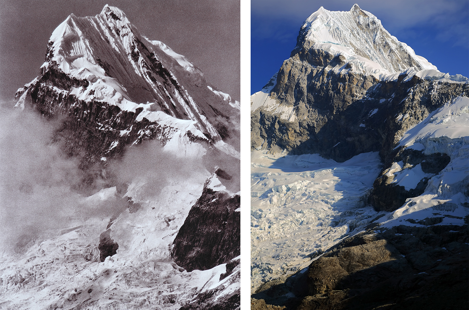
Figure 25. North view of Nevado Chopicalqui. ©DAV, 1939 Figure 26. North view of Nevado Chopicalqui. ©S. Rechitan, 2012
Figures 25 and 26 show another example of the massive glacier recession that has occurred in the Cordillera Blanca since the 1930s. For example, Huascarán North, the highest peak in Peru at 6768 m, has lost several hundred meters of snow and ice cover in the past 73 years. The north summit of Huascarán seems to be the most affected by glacier recession. Substantial ice thinning is also obvious from the comparison of the two photographs. Moreover, the moraine/glacier catchment seems to have experienced substantial geomorphic change, such as moraine wall collapse, increase in surface area, rock and debris avalanches, ice retreat and infill of melt water.
12. Quebrada Llanganuco
Date: 09.08.2012
Aspect: 234°
Altitude: 4493 m
Time: 15:31
Map Station: S41
Original: DAV, 1939

Figure 27. Quebrada Llanganuco. ©DAV, 1939 Figure 28. Quebrada Llanganuco. ©S. Rechitan, 2012
Quebrada Llanganuco offers excellent views of Huascarán, Huandoy, Yanapaccha and Pisco, the latter being one of the most popular climbs in the Cordillera Blanca, as well as the beautiful lakes Chinancocha and Orconcocha (Figures 27 and 28). Llanganuco Valley is a highly popular tourist destination, partly as a consequence of being included in the great Santa Cruz trek and also because it provides the main access route to Pisco, Chopicalqui and Yanapaccha. Comparison between the two photographs shows an apparent stability in the area covered by the native ‘quenual’ (Polylepis) forest species, and the building of the road connecting the Callejón de Huaylas with Yanama and other cities situated on the eastern side.
13. Carhuaz from Cordillera Negra
Date: 06.08.2012
Aspect: 072°
Time: 12:02
Map Station: S41
Altitude: 2829 m
Original: DAV, 1939

Figure 29. Carhuaz seen from the Cordillera Negra. ©DAV, 1939. Figure 30. Carhuaz seen from the Cordillera Negra. ©S. Jiduc, 2012
Carhuaz village was greatly damaged by the 1970 earthquake. A new city has been built on top of the old one, which has been populated with people from all around the country. According to interviews with local inhabitants, the population of the city has increased significantly in recent years. The street configuration of the city is, however, similar to the old one, although the density of buildings is much greater. An apparent increase in the area covered by non-native Eucalyptus species has also occurred, and there seems to have been a decrease in cultivated area. Glacier recession is also apparent as a comparison between the background glaciers of Nevado Hualcán and Nevado Copa suggest.
14. Panorama of Huandoy, Huascarán and Copa
Date: 06.08.2012
Time: 17:00-18:00
Altitudes: 3810 m and 3850 m, respectively
Map Stations: S9 and S10
Original: DAV, 1939

Figure 31. (Top) Composite panorama of Nevados Huandoy, Huascarán and Copa seen from the Cordillera Negra. ©DAV, 1939. Figure 32 (Bottom) Composite panorama of Nevados Huandoy, Huascarán and Copa as seen from the Cordillera Negra. ©S. Rechitan, 2012
The panorama above provides an overview of the total scale of glacier recession that has occurred on the west side of Cordillera Blanca in the past 73 years. The new location of Yungay city is visible on the left side of Figure xx. There is an obvious increase in cultivated land and contained fields, as well as in the density and size of settlements. New roads have been built, including one traversing the entire cordillera through Quebrada Llanganuco, reaching an altitude of 4760 m. An apparent increase in the non-native eucalyptus forest cover is also shown.
Discussion
The preceding study of landscape changes in the Cordillera Blanca and Cordillera Huayhuash of Peru was performed on the basis of three major parameters: glacial cover, vegetation cover and human influence on land. The results of our study have shown that a relatively widespread and significant glacial recession has occurred in the region since the 1930s, with some glaciers losing between one-third and one-quarter of their size and mass. This recession has been accompanied by an increase in rock and ice avalanches, which in turn have increased the risk and likelihood of catastrophic glacial lake outburst floods. In response, Peruvian authorities since the 1950s have lowered some 35 glacial lakes in the region, using methods from simple ditches to state of the art methods such as drilling through a thousand meters of solid rock and installing valves that allow for the control of the lake’s level. Nevertheless, many of these controlled lakes are now growing in size and volume because of warming trends, once again threatening downstream populations and infrastructure.
The melting of glaciers in the Cordilleras Blanca and Huayhuash is also affecting the vulnerability of Andean communities and their access to fresh water. As glaciers melt, there is a transitory increase in runoff due to mass reduction. Nevertheless, water stored as ice in glaciers is limited, and the apparent increase in runoff is only temporary. In a few decades, after the glaciers have lost substantial mass, a decrease in runoff will follow. This trend will be even more pronounced during the low flow season when the relative contribution of melt water is at its maximum (Baraer et al., 2012). In the next few decades, serious water shortage issues could affect many mountain communities living around the two cordilleras. Other issues confronting both cordilleras include the continued impacts of mining in the form of water pollution, unsustainable adventure tourism, including the growing impacts of improper disposal of solid and human waste, and extreme poverty.
Conclusion
The results of our repeat photographic expedition suggested that widespread glacier recession has occurred in the cordilleras Blanca and Huayhuash since the 1930s. Hydrological changes that have accompanied this loss of glacier mass include the formation of new glacial lakes and an apparent increase in runoff; changes in the flow characteristics of glacier fed rivers; changes in flood severity and frequency; and the presence of glacial lake outburst flood events. Urban expansion, population growth, and an increased human influence on water-glacier systems through the construction of dams and drainage systems have also occurred. An apparent stability in the area covered by native Polylepis species was detected, accompanied by an increase in the area covered by non-native Eucalyptus and Pinus species. Cultivated land has increased in area throughout much of the region, with several exceptions, such as around the settlement of Carhuaz. Of continued concern to both cordilleras will be the environmental degradation and pollution caused by contamination of soil and water resources due to mining activities, unsustainable tourism, improper waste disposal and extreme poverty.
Acknoledgements
I would like to thank my university staff, Dr. Kate Heal, Dr. Wyn Williams and Dr. Anthony Newton, who supported the project and myself from the beginning, providing recommendations and constructive feedback as well as insightful advice. I also thank Christian Silva Lindo, whose knowledge, expertise, patience and hospitality made our expedition logistically possible. I thank, too, the Alpenverein librarians in Innsbruck and Munich and at the National Snow and Ice Data Center for providing valuable historic photographs. I particularly would like to thank the National Geographic Society for supporting the project and providing us the opportunity to stretch our limits and seek further into the field of research and exploration. Special thanks also goes to Mr. Horia Pasculescu, Mr. Razvan Muntianu, Mr. Vlad Lascu, Mr. Glad Varga, Mr. Alin Buda and the rest of my sponsors in Romania, as without their support, the project would have been delayed considerably. Last but not least, I should thank Sorin Rechitan who provided photographic equipment and knowledge, thereby substantially increasing the quality of our material, and my climbing partner, Aurel Salasan, whose patience, dedication and climbing experience made the ascents possible.
Bibliography
Baraer, M., Mark, B. G., McKenzie, J. M., Condom, T., Bury, J., Huh, K., Portocarrero, C., Gómez, J. and Rathay, S. (2012). Glacier recession and water resources in Peru’s Cordillera Blanca. Journal of Glaciology, 58(207), 134-150.
Byers, A. C. (2000). Contemporary landscape change in the Huascarán National Park and buffer zone, Cordillera Blanca, Peru. Mountain Research and Development, 20(1), 52-63.
Cuéllar, A. D. (2016). Climate change adaptation to increasing risk of glacial lake outburst floods: Decision making methodology for risk management applied to Imja Lake in Nepal and Lake Palcacocha in Peru. Ph. D. Dissertation, University of Texas at Austin.
Frimer, J. (2005). Climbs and treks in the Cordillera Huayhuash of Peru. Squamish, British Columbia, Canada, Elaho Publishing Corporation.
Kinzl, H. and Schneider, E. (1950). Cordillera Blanca (Perú). Innsbruck, Austria, Universitäts–Verlag Wagner.
Ricker, J. F. (1977). Yurac Janka. A guide to the Peruvian Andes, Part 1: Cordilleras Blanca and Rosko. Banff, Canada, Alpine Club of Canada.
Rivas, D. (2012). Term report. Glacier lake outburst flood (GLOF). Palcacocha Lake, Peru. Environmental and Water Resource Engineering Program. University of Texas at Austin.
Somos-Valenzuela, M. A. (2014) Vulnerability and decision risk analysis in glacier lake outburst floods (GLOF). Case Studies: Quillcay sub basin in the Cordillera Blanca in Peru and Dudh Koshi sub basin in the Everest region in Nepal. Ph. D. Dissertation, University of Texas at Austin.
Wegner, S. (2014). Lo que el agua se llevó: Consecuencias y lecciones del aluvión de Huaraz de 1941. Nota Técnica 7 de la serie “Notas Técnicas sobre Cambio Climático”. Lima, Ministerio del Ambiente.