
Building Resilience to Glacial Floods
- Shimshal, Pakistan -
“The reason for our successful survival was due to the customs and traditions of philanthropy. Because if they had not built vandan (area where herders take their yaks for milking) and ghell (shelter for goats and sheep) and if they had not built in the name of God the bridges and trails… then who else would have cared about us?... This village was built in the name of God… Right from the construction of channels and huts to the construction of houses and trails, our parents, our forefathers and our ancestors spent tremendous resources to build Shimshal...".
— Baig Daula, Shimshal

Figure 1. Entrance to Shimshal Valley during a previous expedition. ©Timothy Taylor, 2015
In a remote corner of Northern Pakistan, at the crossroads of High Asia, lies a remarkable valley called Shimshal. Situated at 3100m, Shimshal is the highest settlement in Pakistan’s northern Hunza region and the last village before the Chinese border. It is reachable only via one rocky road carved into the steep mountains, which is considered one of the world’s most dangerous (Figure 1). This wondrous village is known for its yak herders - those people that the British mountaineer and explorer, Eric Shipton described as the epitome of "hardihood".
"The community of Shimshal is remarkable for its isolation and independence of support from the outside world … They are a happy community leading an ideal existence in magnificent surroundings. The country is sufficiently difficult, and conditions sufficiently severe, to foster in the people that hardihood without which it seems to me impossible for mankind to be content" (Blank on The Map, 1938; reprint 1985, 296).
Shimshal is known for a rather peculiar environmental phenomenon: surging glaciers. While for most alpine areas, scientists are concerned that global warming and retreating ice will swell glacial lakes and increase the risk of floods downstream, Shimshal has the same concern, but for a somewhat different reason. Several of the glaciers that flow into this valley surge, meaning that they cycle through periods of slow flow, when they store mass at elevation and periods of fast flow when they discharge this mass downstream. Since the valley is narrow and has a river running through it, surging glaciers regularly dam the river and create flood hazards. These mountain tsunamis or glacial lake outburst floods as they are known in the scientific community occur when water pooling up behind the tongue of the advancing glacier suddenly breaks through the natural ice dam and cascades down the gorge destroying everything in its path. The cause and relation to a changing climate remain unclear. Hence why, the study of surging behaviour is of paramount importance, given the many lives that are under threat.

Figure 2. Khurdopin Glacier and the dammed Virjerab Lake at Shimshal River. ©Nasa Earth Observatory, 2018
Of these, Khurdopin has surged most recently. After years of little movement, the glacier began a rapid advance in October 2016, accelerating to a rate of roughly 15 meters per day by the spring of 2017—one of the fastest rates globally observed for a mountain glacier. As ice and sediment pushed into the river, a sizable lake pooled up in March 2017 (Figure 2). By July 2017, the river had carved an outlet through the glacial debris before the lake could grow extremely large. In late July 2017, the lake dropped from 100,000 square meters to about 40,000 square meters in a few days—a rapid enough change to produce a flood downstream that damaged bridges, farmland, and a key road. By August 3, 2017, the lake had completely drained. The flooding, damaged the main village road damage and left hundreds of people stranded in Shimshal awaiting evacuation by helicopter, according to the High Asia Herald (Figure 3). Historical records show that surging glaciers have triggered at least 20 of these glacial lake outburst floods over the past century—making the valley one of the most vulnerable in the Karakoram.

Figure 3. Shimshal resident tries to fix an irrigation canal after it was destroyed by a flash flood. ©Ronald Patrick, 2018
The interaction between humans and glacial environments has always been extremely close in the Karakoram. This includes the practice of preserving and growing glaciers intentionally to enhance water availability as well as the use of bonfire early warning systems to reduce vulnerability to glacial floods. This former has become a popular topic in Europe as well in the context of the growing impact of climate change on alpine glaciers (e.g. the Ice Stupa Project Ladakh India). Furthermore, the issue of glacial floods is critical and little information exists on the indigenous knowledge systems surrounding the issues of floods, adaptation and mitigation strategies and long-term water resource management. Collecting comparative information on present and past hazard mitigation and adaptation solutions can provide an excellent narrative on how people cope with a changing climate in the most vulnerable environments. This will help in turn to develop socially and culturally inclusive natural disaster management and prevention solutions (e.g. early warning systems) with high rates of successful adoption and operation.


The Shimshal Expedition
Hypothesising that the lake may form again and grow in the 2018 melt season, which in turn could pose threats to downstream communities in case of a sudden breach, we travelled to Shimshal to bring new insights about the anomalous glacier and help to build the resilience of communities to catastrophic flooding. The journey to Shimshal and Khurdopin Glacier is described in detail here whereas the scientfiic research we carried out on the glacier is described here.
Aims & Objectives

Figure 4. Conceptual model showing the embedded explorative case study research design. ©Sergiu Jiduc, 2018
To create an inclusive and locality-specific system of natural disaster management and emergency response in Shimshal, we explored the indigenous knowledge systems and the cultural and social attitudes towards water resources and flood management using participatory research techniques embedded in an explorative case study research design (Figure 4, Creswell, 2003). This included a series of open space technology focus groups and roundtable discussions and semi-structured interviews. The results from this work enabled us to better understand how these factors affect decision-making and policy development in the region and thus inform adequate flood adaptation strategies. Furthermore, the material from this research will provide a strong input to the media and the storytelling element of the project through the use of anecdotes from the community.
To contribute to the creation of a Community Based Disaster Risk Reduction (CBDRR) programme in Shimshal, we carried out a participatory vulnerability assessment to identify the assets (tangible and intangible) at risk of flooding as well the current and future flood management capacity of the community. Based on the results of this inquiry, we will suggest relevant policy recommendations to local decision makers such as the Gilgit Baltistan Disaster Management Authority. Furthermore, we will advocate the implementation of a catchment-based, integrated water resource management plan, which will account for the ecosystem services and natural disasters in the valley and will include a feasible early warning system rooted in transregional knowledge exchange.
The Community Workshops
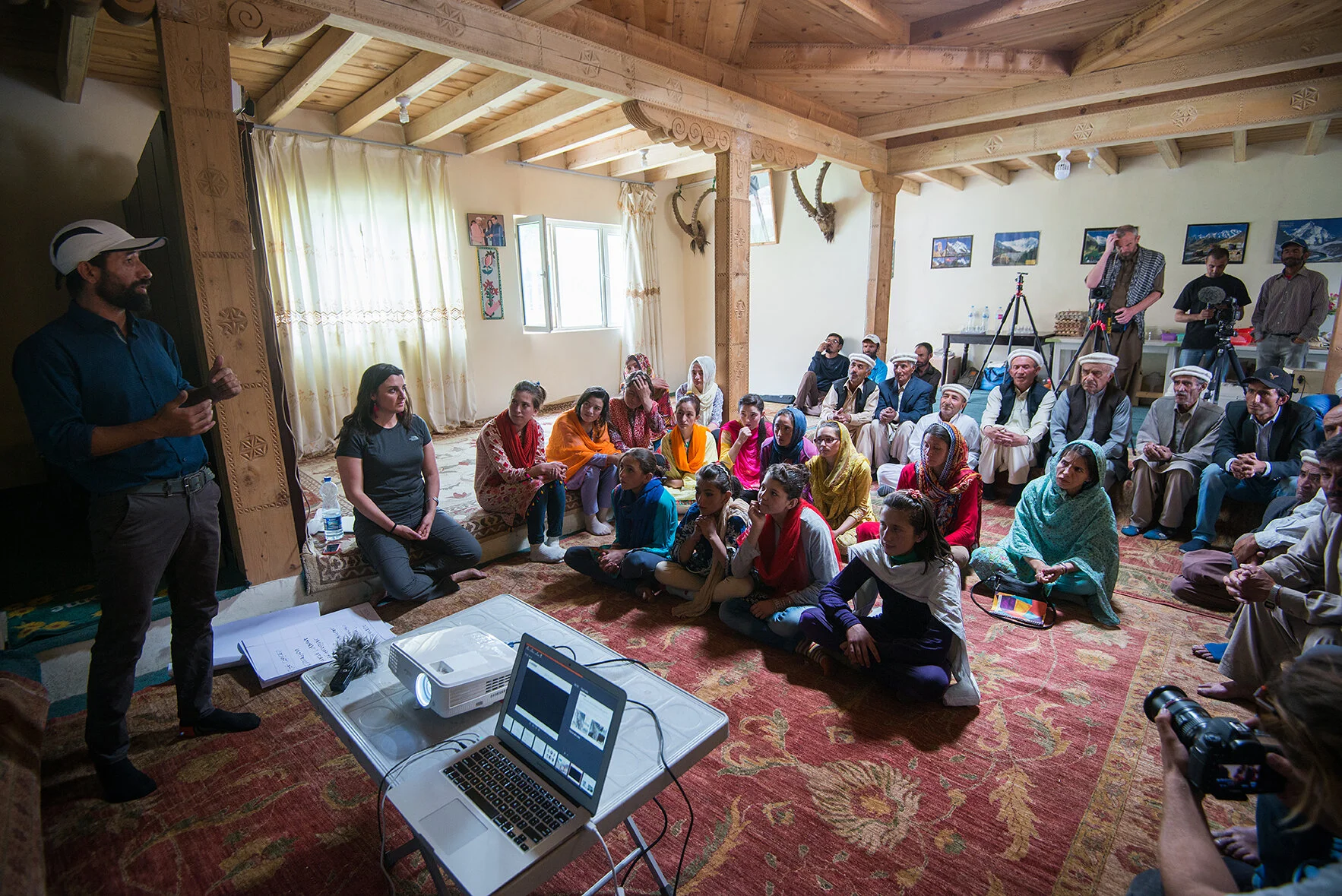
Figure 5. Villagers attend the first day of the capacity building workshop in Shimshal. ©Ana Pavalache, 2018

Figure 6. Women in Shimshal, attending the workshops dedicated to capacity building to glacial floods. ©Ronald Patrick, 2018.
Part I of the workshops comprised an introduction to the Karakoram Anomaly Project as a whole including the team and the 2015 visit and other previous work (Figure 5). Part II presented the findings derived via remote sensing on the 2017 surge event. This included a quantitative evaluation of elevation, surface ice flow velocity and volumetric changes as well as a description of the methods employed and opportunities for future research (Figure 6). A key message of this session was to outline that remote sensing methods are freely available to anyone and thus hazard assessment can be carried out by community members themselves. The community learned about the characteristics of a surging event and improved their understanding about the various glaciological, geomorphological, climatological and hydrological phenomena occurring in the Karakoram including the so-called ‘Karakoram Anomaly’ – the apparent stagnation and/or expansion of some glaciers in the region such as Baltoro. Furthermore, the Shimshali were introduced to a suite of field tools and methods such as photogrammetry, GNSS Real Time Kinematic (RTK) surveys and many others. We were pleased to hear feedback that even less educated elderly individuals were able to improve their knowledge about the glacial phenomena in the region.

Figure 7. A group of villagers evaluates the vulnerability of community assets. ©Ana Pavalache, 2018
Part IV, the vulnerability assessment included a participatory assessment to identify, assess and rank the vulnerability of assets in the village. This comprised an interactive exercise to draw a village flood risk map and to map out the vulnerability of the tangible and intangible assets to flooding (Figures 7 and 8). Preliminary results suggest that physical assets such as the road, government school, clinic, electricity generation source (hydropower), and irrigation canals are highly vulnerable to GLOFs. Furthermore, individuals identified that the cultural heritage, psychological health and educational system can be highly vulnerable to catastrophic events. People’s life choices such as choice of education (e.g. degree, Geography) and/or mobility are affected considerably by environmental disasters such as GLOFs.

Figure 8. Workshop participants draw a flood risk map of the village. ©Ana Pavalache, 2018
On the other hand, the Shimshali possess an incredibly strong bonding social capital, which enables them to maintain a strong adaptive capacity and emergency response. For example, during our stay in the village, a flashflood occurred, which affected a series of irrigation canals in the southern upper reaches of the village. Some of these canals were completely destroyed by the raging debris flow. As soon as the peak discharge passed, members of the community including children, elderly, females and males, gathered together and began the rebuilding of the water irrigation infrastructure.
Part VI and VII, introduced the audience to disaster risk management policy framework, using also international best-case studies from The International Centre for Integrated Mountain Development (ICIMOD) in Nepal. It focused on capacity building and training, public awareness and education, data management and response, among others. We also carried out a gap analysis to identify and prioritise the missing elements to achieving a comprehensive disaster risk management system in Shimshal, and to communicate their status and needs to the outside world. This session also included an evaluation of key barriers and enablers to GLOF risk mitigation and monitoring measures in Shimshal focusing on monitoring and early warning systems such as the GeoPraevent system installed in Shaksgam Valley, China.
It was clear from the consultations that Shimshalis are used to self-sufficiency. This is due to two main reasons. Firstly, response and recovery resources from the government and other stakeholders, both technical and financial, are insufficient. We can infer that this problem is widespread across Pakistan and will most probably worsen due to the expected increase in disasters, with solutions needing to become more expensive as ‘no or low regret’ options are used up. Secondly, and very importantly, the Gilgit Baltistan region was never formally integrated with Pakistan and does not participate in constitutional political affairs, but it is administratively controlled by the nation. It is entirely dependent on yearly grants from the federal government for development capital and current expenditures, which can make it politically and economically vulnerable, especially considering the extent of GLOF-related threats in the region.

Figure 9. Team at UNDP Pakistan discusses the project activities and main findings. ©Ana Pavalache, 2018
During our short stay in Gilgit we had the chance to conduct several stakeholder consultations. This included a representative of the UNDP Pilot Project who told us the history of the project, and the various challenges faced by the team to gather data, engage stakeholders, and increase awareness of GLOFs and the impacts faced by communities, in a complex and dynamic political and social environment, with limited resources that need to be allocated to prioritized geographies and activities.
The Gilgit-Baltistan Disaster Management Authority warmly welcomed us to their office, to discuss their mandate and interventions in the region – Gilgit Baltistan has in fact a peculiar geography, as it is not part of Federal Pakistan. The staff was busy dealing with responses to the Ghizer district flooding, as well as assessments of the collapsed Shimshal road.
In Islamabad, we carried out two high level roundtable discussions with UNDP Pakistan, Pakistan Meteorological Department, and the Aga Khan Foundation, during which we presented our work and findings and laid out the foundation for a formal collaboration with these two entities. This collaboration will be based on sharing and promoting knowledge and scientific results and media material. In the late afternoon and evening, we explored colourful Rawalpindi, now home to the Pakistan Army, which still shows strong signs of the British colonial past.